Auditing Reserves and Open Space: The Value of Creating Boolean Variables

Vision recently had the privilege to work with the Far North District Council on the Reserves Audit project. Vision’s task was to create the geodatabase to serve as the foundations for future refinement and consultation.
This was one of the projects that appears simple in concept, but quickly became complex once data was collected and parameters identified. Firstly, data was coming from multiple sources in varying states of completion. This included parcel, title, and asset layers combined with ownership, ratings, DoC, and other databases. By the time all data was joined, over 50 columns were merged into a single layers datatable.
The second challenge was to figure out what needed to be extracted from the data. At the highest level, the project was about public and recreational spaces. This however broke into several subcategories depending on the type of public space of interest. Did we need to know whether the public simply had access, if it was publicly owned or managed, if the property was actually road, if the space was named, if the reserve had a designated purpose, what public assets were located on the property, if it was for conservation? The answer was “yes” to all of these and many more.
To aid in answering all of these question and combining the results, a series of boolean variables were created. Though the name may be unfamiliar, boolean variables are very commonly used and often serve as the foundation for more advanced analysis, machine learning, or AI projects. Typically they answer a logic question with one of two mutually exclusive categories (True or False, Yes or No, 0 or 1).
In total, Vision created 15 boolean variables, and an additional 2 categorical variables (similar to boolean but with multiple options). These included:

Once the required indicators were identified, the most time consuming part of the project followed: defining the criteria to calculate each indicator for parcels in the For North District. For example, we wanted to know which parcels are intended for use as road. The actual use is irrelevant; all we need to know is that there is some indication the parcel was set aside for a road propose. But, the answer to this question may be in one of 4 fields, and have several different ways of being indicated within each field.
The first stage required that Vision create summary tables of the fields for known road parcels to see what type of language or values may indicate a road. These were then entered into a selection formula, and the selected parcels reviewed to see if known parcels are missing, or if false positives exist. If known road parcels are missing, the selection formula needs refinement. If false positives exists, a second set of summaries needed to be performed to determine criteria for a de-selection formula. In the end, the criteria to select roads and deselect false positives in the Far North looked like this:
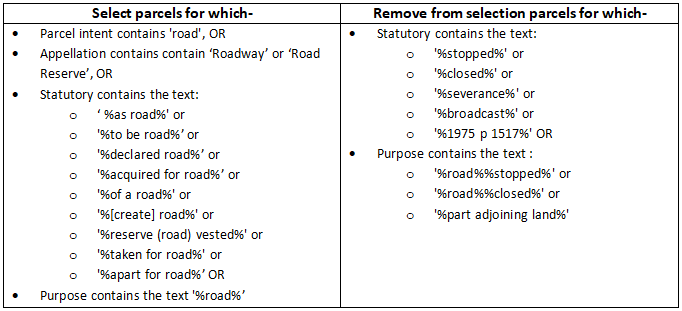
This process was performed for each of the 17 indicator variables created by Vision. With the hard part over, we were left with indicator fields that simplified the assessing open spaces in the Far North District. To demonstrate: let’s say we wanted to know every parcel that was indicated as Road or Maori purpose AND also had a Conservation or Reserve indicator. With the boolean variables, this is a relatively short expression. Without, we would have to script a convoluted selection formula.

Hopefully the comparison of formulas above highlights the benefit of using boolean variables. The time spent up front creating the indicators saves a lot more down the road. We can easily mix, match, assess, and analyse parcels across several different overlapping indicators. If we did not have these fields, we would have to script together all of the selection criteria required; each query would become long, messy, and likely impractical to the point it may not be worth trying.
In closing I should reiterate that this was the first step in the Reserve Audit work for FNDC, but the data is not perfect. This reflects some of the issues that come with large data sets that cover many decades such as parcel and title data. Changes in recording methods, language, standards, and entry can contribute to missing or inconsistent data over time. Notwithstanding, it was a big first step that identified the bulk of public and open space in the far North, and we look forward to seeing how FNDC refines the product.